Working north-east from the station, our first sighting is this building on a not-too-pedestrian friendly junction. The main road to the left of the picture is called The Silk Road, which conjure sup all sorts of romantic images, none of which pertain to the pollutant-laden intrusive reality.

The building is Arighi Bianchi, a furniture store which, judging by how busy its parking attendant was, is doing a roaring trade.

Arighi Bianchi might not sound like a native Macclesfield name, mainly because it isn't. The company's website (www.arighibianchi.co.uk), which has an excellent section on the firm's history, tells the story:
Antonio Arighi Arrives in Macclesfield
Our story begins in 1854, with a long journey on foot from the shores of Lake Como in Northern Italy, over the Alps and across central Europe. Our young adventurer, Antonio Arighi, heads for the silk town of Macclesfield in the North West of England.
On arrival, he sets up shop, making clocks and barometers which he lends out to farmers on sale or return – a canny innovation that proves a real money-spinner.

The company set u in an old silk mill, which in 1892 was renovated and gained a new four-storey extension "inspired by Joseph Paxton's famous Crystal Palace". Unfortunately my photos don't show this part of the building.

Not far away, and even more difficult to navigate to on foot, is a Tesco superstore.


It is a Tesco store. Full marks for having a clock, and a multi-faced one at that, but there is nothing much else to say.

We now move away from The Silk Road and along Hurdsfield Road. Welcoming us is the Holy Trinity church.

Holy Trinity dates from 1839, although the clock is a later addition of 1876.


From Holy Trinity, my route took me down Fence Avenue, past Victoria Park with its fine bandstand (which my book "Bandstands of Britain" by Paul Rabbitts tells me is by Walter MacFarlane & Co of Glasgow and dates from 1894) and along Buxton Road. I was in search of a clock which perched on top of a building on the corner of Union Road. Sadly this clock is no longer there, but my consolation was to spot the following clock in the new housing development of Roan House Way.


A local resident suggested that the clock was reclaimed from an old mill, but I haven't yet found any evidence of this, or any information on Roan House.

We are now off down Black Road until it meets Windmill Street, in search of our second church of the day.

St Peters was built in 1849.


Our next clock is a wall-mounted one on the outside of the Grosvenor Shopping Centre on Castle Street. I have no information about this clock, and particularly why it is there.


Another church, and one that dominates the view from many vantage points. This is St Michael, which has a history dating back to the 13th century.


As usual with churches of this age, it has been modified and re-built many times, notably in 1740 and then again in 1901. The pictures above were taken in the rain at 1pm, but you can see below that the day did eventually brighten up.


Pictures of then and now photographs of towns are often a good source for tracking down clocks (although often a disheartening reminder that many fine examples have been lost). This next location is a direct result of flicking through such a book in the local Waterstones.

This is a car park on Hibel Road at the junction with Jordongate.


The Clock Tower building was once part of Macclesfield Hospital, but was converted into flats in 2011. it can be found by the junction of Cumberland Street and Prestbury Road.


at the junction of Cumberland Street and Chester Road.


The mill dates from the 1820s, originally as part of the local silk industry, but also but to use as a card factory and joinery over its lifetime.


A long walk down Chester Road brings us to 151 Broken Cross. I know very little about this clock or the property, other than it is a shop with a clock.


The older building in question is Parkside Hospital, which was an asylum opened in May 1871.

The building can best be viewed from Victoria Road (which avoids the circuitous route around the new residential streets that I had to take approaching it from Chester Road).


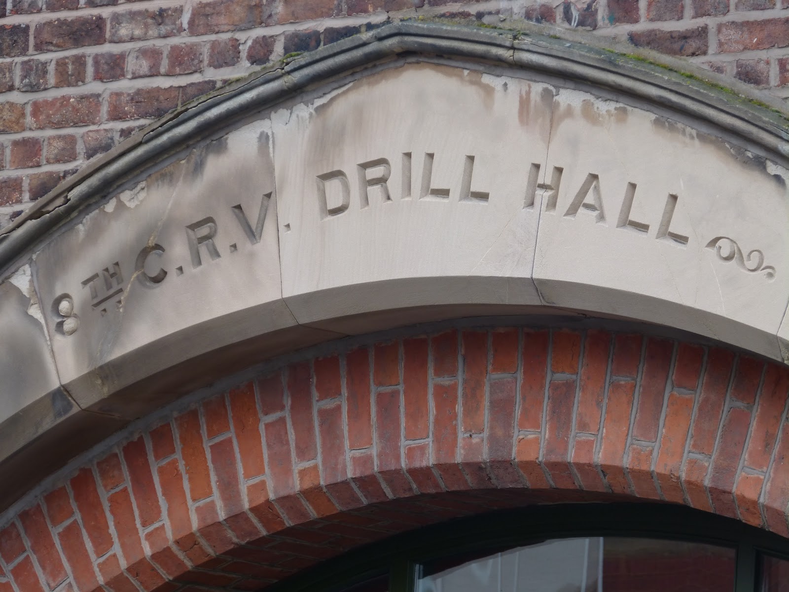
We are back in the main part of the town again, more specifically in Bridge Street.

The Drill Hall was built in 1871 for the 8th Cheshire Rifle Volunteers. Like Parkside Hospital, it has since been converted into residential use. Which probably explains why there is a clock face (indeed several) without any hands.


Further south on Bridge Street is Christ Church.

Although it has not been converted into residential use like the Drill Hall and Parkside Hospital, it has been disused since 1981, having been built in 1775.


Just one more clock to go. And of course this is an old building that has been converted for residential use. It also refers back to the military history of Drill Hall, as this is Barracks Square on what was, of course, the old army barracks, built in 1836.


